Everest expeditions involve considerable logistics and planning. Our initial team consisted of 8 climbers (from six countries), 4 guides and a support group of 45 Sherpa. We utilized 120 yaks to carry four and one half tons of supplies and equipment from from Lukla fifty miles to base camp, roughly 17,500 feet above sea level.
Our climbing plan allocated over seven weeks to establish higher camps, acclimatize and climb the mountain. This included twenty days for weather delays. The plan called for us to establish and maintain five camps simultaneously at different elevations.
Rather than gain and hold altitude in incremental steps, we completed a series of stages, each time descending back to base camp or lower to recuperate. This allowed the summit team to make acclimatization climbs, descend and recover from brief exposures to higher altitudes. With everything in place, the team could then make one continuous summit push timed to take advantage of even a brief weather window.
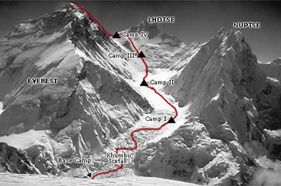
Pictures and select narratives of our 2003 expedition to Everest are presented in eight segments, corresponding to the elevations on the map (right):
1. Travel to Katmandu and trek from Namche Bazaar to Base Camp
2. Base Camp
3. Khumbu Icefall and Camp I
4. Western Cwm and Camp II
5. Lhotse Face and Camp III
6. Geneva Spur and Camp IV
7. Summit Bid, including Southeast Ridge and Hilary Step
8. Descent to Base Camp, Trek to Lukla, return to Katmandu and home.
|
Everest Route Map
 Everest
route map courtesy of Alpine Ascents Everest
route map courtesy of Alpine Ascents
_________________________________________________________
Summary of our Camps and Climbing Excursions:
Base Camp: 17,500’ We arrived 12 April and departed June 2, 2003.
Camp I: 19,500’ We climbed through the Khumbu icefall to Camp I on four occasions.
Camp II: 21,500’ Three times we continued above Camp I, through the Western Cwm to Camp II.
Camp III: 24,000’ Twice we continued above Camp II, and climbed the Lhotse Face to Camp III.
Camp IV: 26,300’ We made one push up above Camp III, through the Yellow Band, over the Geneva Spur to Camp IV at the South Col.
Summit: 29,035’ After four days at Camp IV, we climbed the Southeast Ridge, South Summit and Hilary Step, and arrived at the summit at noon on May 30th, 2003. |

)